Maps

Joined
Jun 17, 2010
Messages
118
Likes
2
Feedback: 0 / 0 / 0
Hey Everyone,

Now that I have finally flown the nest (Rent and Bills SUCK!!!), I am finally able to do things that I have wanted to do for sometime. First one?? Building a Bug-out bag.

First thing that I have found was a street map of my hometown, put out by my local chamber of commerce and made/published by MapGuys (27 Water Street Wakefield,MA).

I have done some google searches, but nothing comes up, except for the above address. Any idea if they have a website??

Any recommendations on map retailers??

Sean Hickey
 
How much detail do you need in your maps? For my local county I stick to the USGS maps. Plenty of detail, the most recent edition is only a couple of years old, etc
if it was for an area I wasn't in so often, I could see going with a cheaper less detailed product
 
For MA you can use the Oliver system. I'm on my phone otherwise I'd give you a link. It allows you to turn on all sorts of features, which can be very handy. I also use CalTopo which has a handy interface.

If you're printing them for bug out purposes or even hiking/camping you might consider a laminating machine. I got one on Amazon with 100 pouches for pretty short money. That keeps it waterproof and you can write on it.


Sent from my iPhone using Tapatalk
 
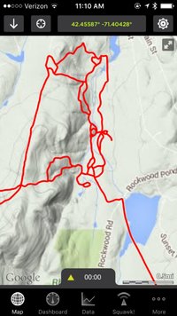
I use an iPhone app called GPSKit for ATV and snowmobile riding.

IMG_1799.jpg

There are sites that sell map tracks for all the trail systems in New England. The app lets you download the base map tiles so you won't need cell service to use the maps.
 
I use an iPhone app called GPSKit for ATV and snowmobile riding.

View attachment 173136

There are sites that sell map tracks for all the trail systems in New England. The app lets you download the base map tiles so you won't need cell service to use the maps.
There is another app that does something similar... backcountry navigator? Last time I looked it was ~$15.
 
I think we should all have a lot of paper maps in our preps. In a SHTF situation where the power and internet are out, our phones and computers will be of no use.
 
I think we should all have a lot of paper maps in our preps. In a SHTF situation where the power and internet are out, our phones and computers will be of no use.

on a contrary, there are a lot of equipment that can hold libraries of shit and can be powered by very small amount of electricity. It's small, easy to transport and contains pretty much you may ever need.


USGS maps are fantastic, there are many layers available for most locations, elevations etc. The only think it doesn't have are special features like woods density for tracked vehicle mobility, but you can create your own custom layers and add if you wish.
 
I think we should all have a lot of paper maps in our preps. In a SHTF situation where the power and internet are out, our phones and computers will be of no use.

But how will I tell where the official NES meeting site is if I can't get on my phone or a computer???? [laugh][laugh]

I've poked around on the US Geo survey website and printed a few topo maps from there, but the website and interface are really awful, IMO. I'm following this thread to see what others like.
 
USGS maps, either paper or not, are the gold standard. I've even been known to print out archived (scanned) versions based on the old 1930s or 1950s data. Still work fine; hilltops don't move.

Critically, though, a good topo map is going to be useless to you without some decent land nav training and experience. It's also just one component, plus compass, declination diagram, and protractor. The map itself is only good for using the IFR technique.

IFR = "I follow roads."

eta: hey OP, Map Guys closed awhile ago I think. They were right across from the Wakefield train station. Great little store.
 
Last edited:
USGS maps, either paper or not, are the gold standard. I've even been known to print out archived (scanned) versions based on the old 1930s or 1950s data. Still work fine; hilltops don't move.

Critically, though, a good topo map is going to be useless to you without some decent land nav training and experience. It's also just one component, plus compass, declination diagram, and protractor. The map itself is only good for using the IFR technique.

IFR = "I follow roads."

eta: hey OP, Map Guys closed awhile ago I think. They were right across from the Wakefield train station. Great little store.

Kinda Figured they closed. I ran a couple Google Searches, and nadda.

- - - Updated - - -

How much detail do you need in your maps? For my local county I stick to the USGS maps. Plenty of detail, the most recent edition is only a couple of years old, etc
if it was for an area I wasn't in so often, I could see going with a cheaper less detailed product

I am basically looking to get street maps for my immediate area. Boston, Everett, Medford, Somerville, Melrose, Revere, etc. Then of course get Topographic maps down the line as well.
 
http://www.mytopo.com/?gclid=CIXnl4nOlqYCFcTb4AodVRJ_mw

A friend of mine show me a custom map he had made from these guys. It was pretty nice.

If you are looking for USGS topo maps, this MYTOPO link is a good option to creating a custom grid for your area. The USGS maps cover specific sections of an overall grid of maps. I have 4 of them that covers the immediate area around my home as far as the nearby towns that I frequently travel. However, I made a custom map with MYTOPO that essentially centers my home on one map that uses the USGS images. This is a good go to map to simply master your immediate area.
 
Atlases put out by the DeLorme company in Maine have a good amount of detail and are easy to use. https://shop.delorme.com.19.95 for each book, I'm not sure they have every state, but most are there. I use these for boating, hiking, camping etc.

Love Delorme. They are a literal one stop shop for maps. I plan on using them big time. But I do plan on getting fold up paper maps as well.
 
and laminate them, wet paper is no good, and I can't read fogged blurry electric devices.

Forgot about this. You can order the maps on different types of paper and I would definitely agree with the laminated paper recommendation.
 
Back in the 90's I used to get the Delorme books and USGS topo maps at my local office/stationary store, don't know if you still have those where you are. EMS should have them, or other outdoor sports type stores.
 
You might like the recent development from the National Geographic regarding FREE USGS printable maps.

Print them out on "Adventure Paper" and you can get some nice maps that have not been easily available.

https://shop.nationalgeographic.com...adventure-paper:-waterproof-ink-jet-map-paper

FREE!! Printable USGS PDF Quads

http://www.natgeomaps.com/trail-maps/pdf-quads

A Quick, Easy, and Free way to Download any Quad in the Country

National Geographic has built an easy to use web interface that allows anyone to quickly find any quad in the country for downloading and printing. Each quad has been pre-processed to print on a standard home, letter size printer. These are the same quads that were printed by USGS for decades on giant bus-sized pressed but are now available in multi-page PDFs that can be printed just about anywhere. They are pre-packaged using the standard 7.5 minute, 1:24,000 base but with some twists:
Page 1 is an overview map showing the Quad in context
Pages 2 through 5 are the standard USGS Quads cut in quarters to fit on standard printers
Hillshading has been added to each page of the PDF to help visualize the topography
 
Back
Top Bottom