-
If you enjoy the forum please consider supporting it by signing up for a NES Membership The benefits pay for the membership many times over.
You are using an out of date browser. It may not display this or other websites correctly.
You should upgrade or use an alternative browser.
You should upgrade or use an alternative browser.
Springfield Armory History Question
- Thread starter TFLeader
- Start date
RichM
Retired Army Veteran
Does anyone know the location of the Springfield Armory's Birchem Bend test range? Brophy's book says it was about 2 miles from the Armory.
Birchem Bend brook, Springfield, MA
Wow, that's right near me! It's a sharp cut little valley across from the Post Office sorting facility...
ETA: It appears that the bend in the Chicopee River is the Bircham Bend...
Last edited:
RichM
Retired Army Veteran
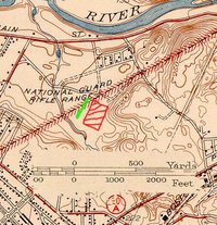
I found this USGS survey map from 1938... and look what I found!
Look west of the Bircham Bend... at the National Guard Rifle Range!
... and this updated map from 1947...
Look west of the Bircham Bend... at the National Guard Rifle Range!
... and this updated map from 1947...
Last edited:
From the internet:
U.S. bolt rifles were zero'd for point of aim = point of impact (POA=POI). The aim point on the target looked like an inverted capital letter "T". At Springfield Armory, the firing was done on the Birchem Bend range which was 200 meters. Yes, that's right, meters. Don't ask me why, I have no clue, but I've seen in more than one contemporary source. On the M1903, the rear sight was raised to a smidge over the 200 yard mark, and the height of the front sight was regulated to get the elebvation "on" as near as possible. The front sights were made in a range of heights, and marked in decimal numbers which would be invisible when the sight was installed. The "moveable base" of the front sight was also adjusted so that the windage marks on the rear sight baser were zero'd. When this procedure was complete, the "battle sight" (using the notch in the slide cap with the ladder down) was supposed to be 547 yards. AFAIK, there was no facility on or near the Armory to verify that by firing. Also AFAIK, that was determined by calculation. In my own experience with many, many '03's over 40-plus years, that's probably pretty close.
Also if you Google "Birchem Bend range" you will find some nice photos of employees zeroing in 1903's at the range.
Current aerial photos still show the area undeveloped.
Another find:
http://home.nps.gov/ner/customcf/apps/pgallery/photo.cfm?aid=453&pid=5312&gid=453
Use the left right arrow to see other great photos! On the wall of the first photo is the inverted "T" target, I think.
http://home.nps.gov/ner/customcf/apps/pgallery/photo.cfm?aid=453&pid=5312&gid=453
Use the left right arrow to see other great photos! On the wall of the first photo is the inverted "T" target, I think.
RichM
Retired Army Veteran
I spoke to a former Chicopee, MA police officer today and asked him about that range. He knew right where it was, and said further that both Springfield and Chicopee claimed that the land was within their city limits; if you'll notice on the USGS updated map, it looks like the town line bisects that area. After it fell into disuse, Springfield still claimed it belonged to them, but whenever kids got to causing trouble there after dark, Springfield would refuse to send a cruiser to roust them out, so Chicopee had to send in their cruisers.
I'll bet that there's still some evidence of the range there... I'm sure that they shot from north to south, as the land rises significantly to the south... If I was feeling adventurous, I might take a walk there this coming summer.... I'm sure that it's pretty boggy in the spring...
I'll bet that there's still some evidence of the range there... I'm sure that they shot from north to south, as the land rises significantly to the south... If I was feeling adventurous, I might take a walk there this coming summer.... I'm sure that it's pretty boggy in the spring...
Another find:
http://home.nps.gov/ner/customcf/apps/pgallery/photo.cfm?aid=453&pid=5312&gid=453
Use the left right arrow to see other great photos! On the wall of the first photo is the inverted "T" target, I think.
Great set of pictures! Thanks for posting.
Jim
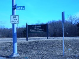
Former Birdhem Bend Test Range
Site visit today. Photo taken form Main and Carew. Several online references refer to UXO Surveys at National Guard Rifle Range at Main and West Streets in Chicopee. A development company want to turn the site into an office park and has put several roads through the property. A windshield survey of the area did not turn up any evidence of range use, but a lot more could have been surveyed by foot.
Site visit today. Photo taken form Main and Carew. Several online references refer to UXO Surveys at National Guard Rifle Range at Main and West Streets in Chicopee. A development company want to turn the site into an office park and has put several roads through the property. A windshield survey of the area did not turn up any evidence of range use, but a lot more could have been surveyed by foot.
Attachments
RichM
Retired Army Veteran
I forgot that they were going to put a business park there... I remember reading about it a few years ago... but I thought that some of that area was wetlands? Are they going to build around them?
I forgot that they were going to put a business park there... I remember reading about it a few years ago... but I thought that some of that area was wetlands? Are they going to build around them?
If you go to: http://www.westmassdevelopment.com/uploads/basicContentWidget/1159/CRBP 08 02.pdf
You can see the proposed development. Would be interesting to see where the range was.
What interesting photos. I love the one to test recoil where they have a pencil attached to the rear to mark a piece of paper how much recoil is generated! Very cool stuff. I think another tour is necessary.
RichM
Retired Army Veteran
OK, I talked to the police officer today... the range was located at the end of Robbins Rd. (not the new Robbins Circle), and the downrange area was to the east. The berm was sand with concrete behind it. This was before Rt. 291 was built. There was a road from Carew St. from the Chicopee side, and it bottomed out in some of the boggy areas; the cruisers would fly through there for fun (as long as they ran through the car wash later).

From his description, the firing line was near the green line, and the impact area was the red cross-hatched area.
From his description, the firing line was near the green line, and the impact area was the red cross-hatched area.
Attachments
Last edited:
the empty bldg on shawinigan dr is the former key club. when i was a kid that was where my familys barn was as my grandfather owned that land. i can remember when they took our land for the turnpike and watching them build it. a couple of years later we sold the rest of the farm to monsanto and moved to belchertown in 1958. fond memories of youthful days there.Birchem Bend brook, Springfield, MA
Wow, that's right near me! It's a sharp cut little valley across from the Post Office sorting facility...
ETA: It appears that the bend in the Chicopee River is the Bircham Bend...
Why doesn't someone re-open this as a gun club?
Why doesn't someone re-open this as a gun club?
For the same reason they don't open up the old Creedmoor range in NY.
B
For the same reason they don't open up the old Creedmoor range in NY.
B
Okay, I might be a bit green here, I don't catch your association.
Share: